
Southeastern will introduce 3D maps at 70 stations and update 69 others, helping passengers navigate stations easily and travel with greater confidence.
Southeastern has announced a major programme to update and improve the online maps for 139 stations across its network, expanding access to clearer, more accurate, and accessible station information for all passengers.
Following the successful trial of 3D station maps for 25 stations over the past 18 months, Southeastern will now introduce 3D maps for an additional 70 stations. A further 69 stations will receive updated 2D maps reflecting recent upgrades and improvements. All maps will also become available on the Southeastern website for the first time, as previously they were only accessible via the National Rail Enquiries website.
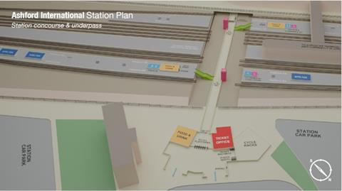
The 3D maps are designed to provide a more accurate, to-scale representation of each station layout, helping customers identify facilities and accessibility features. They aim to make journey planning easier and more independent, especially for those travelling through stations they have not visited before. The maps offer a clearer sense of space and scale, reducing confusion and improving overall navigation.
The rollout of the 3D and 2D maps is expected to be completed by the end of March 2026. Once finished, more than two-thirds of Southeastern’s stations will feature modern 3D mapping, enhancing accessibility and confidence for passengers across the network.
Tina Owusu, Head of Inclusive Customer Experience at Southeastern, said:
“We are always working to find new and better ways to help customers travel with confidence. The programme to improve station maps will mean over two-thirds of our stations will have more modern and accessible 3D maps by the end of March 2026, while the remaining 69 station maps will be updated to capture recent upgrades and improvements to facilities. We believe these improvements will make a big difference to all customers, but particularly those with accessibility requirements or those travelling to a station for the first time.”
The initiative follows a growing emphasis on improving accessibility and digital inclusivity across the rail industry. The trial demonstrated that passengers found 3D maps more intuitive and easier to use, especially when identifying lifts, toilets, ticket machines, help points, and step-free routes. By offering a detailed visual guide, passengers can plan their journeys more confidently before arriving at the station.
Stations receiving the new 3D maps include major commuter and regional hubs such as Greenwich, Rochester, Maidstone East, Folkestone Central, Beckenham Junction, Canterbury East, Margate, and Whitstable, among others. The rollout will also include smaller community stations, ensuring consistency and accessibility across the network.
The 69 stations receiving new 2D maps include locations such as Hither Green, Brixton, East Malling, New Beckenham, and West Dulwich. These updated 2D versions will capture new layouts and facilities following recent station improvements.
Southeastern’s completed 3D maps already cover key stations including Ashford International, Canterbury West, Chatham, Dartford, Gillingham, Lewisham, London Waterloo East, Orpington, Sevenoaks, Tonbridge, and Tunbridge Wells.
This mapping project is part of Southeastern’s wider digital accessibility strategy, which aims to support all passengers in travelling with ease and independence. The company continues to invest in inclusive design and technology to enhance the passenger experience both online and on the network.
By March 2026, Southeastern’s enhanced mapping system will form a key component of its customer service improvements, reinforcing its commitment to accessibility, passenger confidence, and modern, user-focused travel information.