Satellites and drones to support railway infrastructure maintenance
Posted: 8 June 2019 | Valeria Donzelli (MOMIT) | No comments yet
The MOMIT project aims at developing and demonstrating a new use of remote sensing technologies for railway infrastructure monitoring. Here, Valeria Donzelli, Project Coordinator, explains how the solutions to come from the project will support the maintenance and prevention processes within the infrastructure management lifecycle.
Infrastructure accounts for approximately one-third of a railway’s operating costs. A significant part of these costs is related to labour-intensive maintenance, most of which is preventive, although ad hoc interventions are also needed when faults occur, and these can be particularly costly and disruptive.
The reduction of the system costs relies heavily on the reduction of the operating costs, not only directly through better maintenance strategies and procedures which allow for cost efficient predictive maintenance, but also indirectly through the reduction of the life-time cost of infrastructure assets and hence relevant maintenance.
Innovative technologies could support infrastructure maintenance: Improved asset information based on remote infrastructure condition monitoring, with a high degree of automation, could lead to wider asset control and, at same time, to sensible reduction of infrastructures maintenance costs.
The Shift2Rail Joint Undertaking is the first European rail joint technology initiative to seek focused research and innovation and market-driven solutions by accelerating the integration of new and advanced technologies into innovative rail product solutions: The Shift2Rail programme offers the opportunity to find and test innovative technologies and procedures which are able to support the asset management.
In the framework of the Shift2Rail programme, the MOMIT project ‘Multi-scale Observation and Monitoring of railway Infrastructure Threats’ has been presented: Aimed to develop innovative products and solutions supporting the maintenance process of railway infrastructure. The MOMIT concept is based on the exploitation of unmanned technologies as Earth Observation satellites and drone-borne sensors for railway management support: It impacts on the railway infrastructure maintenance process by boosting the use of remote sensing data and unmanned technologies to generate new effective solutions in terms of products (value added information) and processes (operational workflows). MOMIT also analyses the main technological and regulation barriers that separates the remote sensing community from the operational use of Earth Observation data in the domain of infrastructure management. This develops new easy-to-adopt solutions (for example the use of standard parameters to identify potential findings), supporting the decision-making and maintenance process of the infrastructure management.
THE MOMIT project
MOMIT’s core is resumed into the following four objectives:
- To bring at cutting-edge level the remote sensing technology applied to railways infrastructure monitoring for both drone and satellite-based solutions
- To demonstrate value adding capabilities of satellite data, which are able not only to integrate standard technologies (including in-situ data and drone-based monitoring) but also to complement or substitute them in some cases, with evident benefits in terms of costs, reliability and coverage
- To develop new platform independent tools supporting data analysis and the decision-making process
- To define operational criteria for an effective and efficient use of unmanned technology highlighting benefits, complementarities and limitations with respect to standard monitoring technologies, considering economic and sustainability criteria for the adoption of the developed solutions based on clear evidence derived by in field demonstrators’ results.
The MOMIT project is under realisation by a consortium composed by:
- Project Coodinator – E-GEOS SPA (Italy), as satellite geo-information service provider
- Railway ICT engineering solution – NEAT SRL (Italy)
- Drone service provider – Terabee SAS (France)
- Remote sensing data processing technology – Centre Tecnologic de Telecomunicacions de Catalunya (CTTC, Spain)
- Remote sensing data interpretation – Universidad de Alicante (Spain)
- User – Rete Ferroviaria Italiana (RFI, Italy).
In the MOMIT project, satellite and drone data are combined in order to maximise their benefits and characteristics. Starting from data analysis, MOMIT designs new operational workflows able to support intelligent asset management, by developing advanced post-processing chains, data fusion, automation and defining new indicators from estimated parameters to detect real asset condition and to support maintenance based on risk-based or condition-based analytics.
The effectiveness and efficiency of remote sensing use on railway infrastructure management is demonstrated by means of six main application cases, validated in a real operational environment:
1. Monitoring of ground movements near infrastructure
Starting from interferometry derived by SAR satellite data analysis, tools and indicators are defined to support the user in the monitoring of already known and identification of new phenomena. Figure 1 shows a railway line affected by a landslide that has been detected by means of PSP-IFSAR, interferometric analysis from Cosmo SKYmed satellite data.
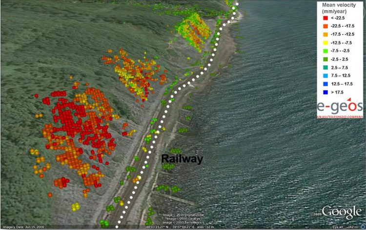
Figure 1: A railway line affected by a landslide that has been detected by means of PSP-IFSAR, interferometric analysis from Cosmo SKYmed satellite data
2. Monitoring of hydraulic activities near track
A combination of optical and radar satellite data is used to monitor soil moisture and water bodies close to the track and to timely alert of potential flood. Figure 2 provides an example of a flood event assessment map.
3. Global supervision for natural hazards
Anomalies along the track related to natural phenomena (as vegetation growth) are monitored using satellite data.
4. Electrical system monitoring
A drone equipped with innovative sensors can observe electrical effects impacting on the infrastructure efficiency.
5. Civil engineering structures monitoring
A combination of satellite and drone data is used to identify possible criticalities to the infrastructure, with possibility to build up a 3D model from acquired data.
6. Safety monitoring
Anomalies and illicit activities along the track are detected and controlled using optical and radar satellite data.
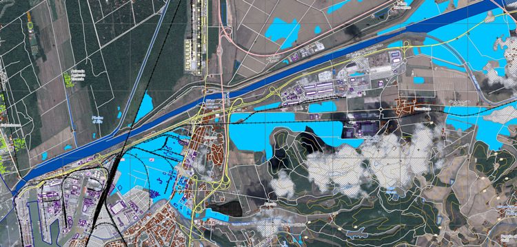
Figure 2: An example of a flood event assessment map
The MOMIT project includes a rich set of innovative technical aspects related to railway infrastructure monitoring. These aspects generate new, original and more effective tools to address specific monitoring tasks. They represent a remarkable improvement with respect to existing and currently used monitoring procedures, which often require manual, cumbersome, not completely safe, time-consuming and costly operations. The improvement concerns the automation of the monitoring tasks, the decrease of their cost, the standardisation of the monitoring operations, the increase of the safety of the operations and the increase of accuracy, precision and repeatability of the monitoring. The remote sensing monitoring implies an enormous economic advantage, cost reduction and safety increase, as no personnel walking along the line or on helicopters, and risk reduction to personnel. Moreover, this implies increased safety of personnel and time saving – quick surveys can be carried out as no need to disrupt train schedules.
In addition to the innovation related to single technical aspects, MOMIT contributes to the development of a highly integrated and automatic monitoring system, which is focused on and tailored to real user needs. The innovation value of such a system is even higher than the innovative character of the single system components. Some of these components have been already used in other application contexts but have been not yet experimented and assessed in the specific application at hand. A major effort has been made to implement engineered processing chains, thus guaranteeing a high degree of automation for the processing and analysis of remote sensing data.
MOMIT is a technological project driven by the needs of the public and private companies in charge of railway infrastructure monitoring. The aim of the project is that the solutions developed will be integrated into the daily operational workflow of infrastructure monitoring and management. By using and exploiting these innovative system products, some important advantages are expected. The first straightforward advantage is the improvement of the railway maintenance operations effectiveness. The project has the ambition to address different railway infrastructure monitoring needs, in particular those related to the reduction of any operation that can cause a slowdown or interruption of the service. By using satellites and drones, there will be no need to block the train circulation along the track for monitoring purposes. Another advantage is the capability to perform safe maintenance operations. In fact, the visual inspection of the infrastructures will be reduced. A third advantage is the Life-Cycle Cost (LCC) reduction, thus contributing to achieve a cost efficient and reliable infrastructure. A more effective monitoring and maintenance management will contribute to improve the railway reliability and capacity.
Acknowledgement and disclaimer
This project has received funding from the Shift2Rail Joint Undertaking under the European Union’s Horizon 2020 research and innovation programme under grant agreement No. 777630. This publication reflects the author’s views. The Joint Undertaking is not responsible for any use that may be made of the information it contains.
 Valeria Donzelli is Project Manager for e-GEOS S.p.A., a leading international player in the Earth Observation and Geo-Spatial Information business. She has more than 25 years’ experience in the satellite and remote sensing application for environmental management and monitoring. Valeria’s experience spans project management, algorithms analysis and implementation, technical support to commercial proposal and consultancy across a variety of environmental application, including land, ocean and atmosphere. She holds a master’s degree in Physics from the University of Palermo, Italy.
Issue
Related topics
Big Data, Digitalisation, Drones, Track/Infrastructure Maintenance & Engineering