How Network Rail’s National Aerial Survey takes digital twin benefits to new heights
Posted: 19 April 2022 | Atkins, Mark Fielding-Smith | No comments yet
Mark Fielding-Smith, Client Director, Digital Rail at Atkins, explains how they have supported Network Rail’s National Aerial Survey and how this helps the infrastructure manager utilise data and take digital twin benefits to new heights.
Credit: Network Rail
Data is transforming how we make decisions. Rather than simply reacting to events, high-quality datasets enable us to predict and prevent service affecting failures, saving money, time, and transforming how assets are managed whilst making services safer for customers and asset managers. However, while many organisations aspire to this state, few have a tangible plan of how to achieve it. Realising the benefits of the digital twin demands a deep understanding of the data, engineering, asset management and railway operations.
Our support in delivering Network Rail’s National Aerial Survey demonstrates how the proper gathering, timely processing, and analysing of data improves the passenger experience, reduces trackworker safety risk exposure, and paves the way for the digital twin.
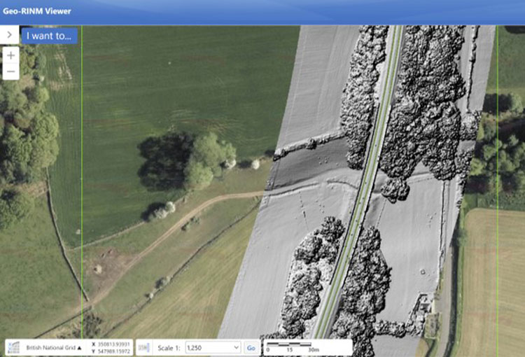
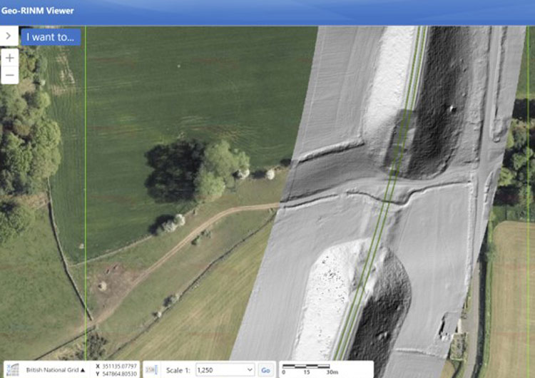
Network Rail manage 20,000 miles of track. Doing this effectively demands accurate, reliable, up-to-date data with the requisite quality to inform critical decision-making. One of the most important datasets enabling this is geospatial data derived from aerial surveys. Aerial survey information is vital for day-to day operations across Network Rail. As experts in digital aerial survey in the railway, Atkins, working with a range of suppliers, helped deliver Network Rail’s geospatial data management system, Geo RINM Viewer (GRV), which Network Rail use to visualise the data. With this domain expertise, Atkins was selected to help refresh the national aerial survey dataset. Spanning England, Wales, and Scotland, the Atkins aerial team was tasked with managing a three-year project to capture, process, quality assure and upload 16,850km of aerial data into GRV.
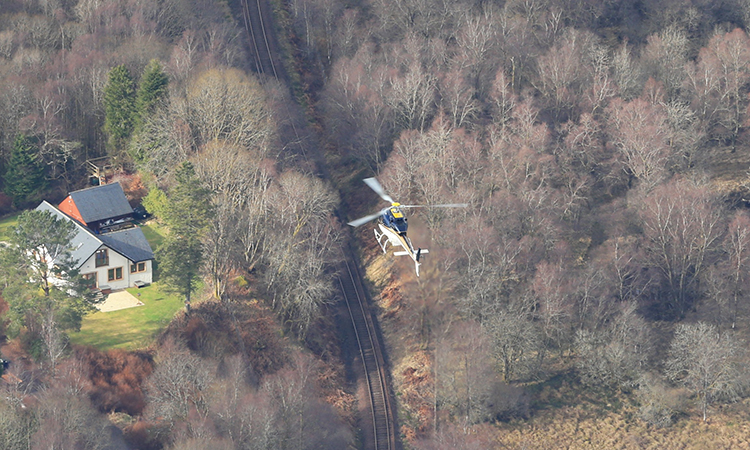
To achieve the best quality dataset, the aerial survey team can capture high resolution aerial photographic imagery and 3D light detection and ranging (LiDAR) data to develop 3D digital terrain and surface models. Credit: Network Rail
The challenges were enormous, but so were the targeted benefits. High quality aerial data combined with innovative decision support tools help Network Rail to predict and prevent failures, for example using the award winning vegetation encroachment application. This kind of data allows Network Rail’s operations and maintenance teams to visualise and understand what they need to do before they go on site, as well as identify and mitigate safety risks, such as finding appropriate site access. This allows staff to be more productive whilst on site, making the most of possessions and in turn minimising disruptions to customers and freight users.
Accurate, up-to-date aerial data can enable Network Rail to pinpoint the incident’s origin, potentially unearthing insights that will help stop future recurrence.
Even when things do go wrong, aerial survey data can help. It supports root cause analysis, which seeks to determine exactly how and why an incident occurred. Accurate, up-to-date aerial data can enable Network Rail to pinpoint the incident’s origin, potentially unearthing insights that will help stop future recurrence. It can also help emergency services to locate the best point of access and to survey the terrain remotely to ensure that they have the right equipment.
Weathering the storm
To achieve the best quality dataset, the aerial survey team captured high resolution aerial photographic imagery and 3D light detection and ranging (LiDAR) data to develop 3D digital terrain and surface models. This required teams on the ground as well as in the air, using a range of technologies to ensure the accuracy of the output data.
So how do you actually go about capturing such a vast amount of data? One big problem we encountered was the weather. Helicopters can only fly safely in certain conditions as bad weather makes for low quality images. Unpredictable weather patterns can also lead to unexpected delays, making it difficult to adhere to a schedule. This was exacerbated by the fact that we were compelled to survey the track in the winter. During the rest of the year, the ground would have been obscured by vegetation, making both the photographic and LiDAR data less accurate and harder to use for earthworks assessments. But winter poses its own problems. Not only is the weather less favourable to flying, there are also fewer hours of light in which to capture usable imagery.
To achieve the best quality dataset, the aerial survey team can capture high resolution aerial photographic imagery and 3D light detection and ranging (LiDAR) data to develop 3D digital terrain and surface models. Credit: Network Rail
Yet the biggest challenge we found, by far, concerned the sheer scale of the data. Terabytes upon terabytes of high definition data demands hardcore data management skills. The differing formats, storage needs, and quality assurance metrics require a high-level and complex skillset. Atkins world-leading geomatics team worked together with data experts to develop the processes necessary to handle that data, assure its quality, and ensure its successful integration. Without these vital skills, a data capture project of this scale would have been challenging and difficult to complete.
Experience, expertise – and no excuses
Three key elements were vital to the successful delivery of the programme.
Many of the technical challenges involved in aerial surveys are non-obvious; it is far more complex than just sticking a camera onto a helicopter and sending it into the sky.
First was our experience and abilities in aerial surveying geomatics and geospatial data management. Many of the technical challenges involved in aerial surveys are non-obvious; it is far more complex than just sticking a camera onto a helicopter and sending it into the sky. In order to support Network Rail’s decision-making, the photographs need to be at a very high level of accuracy. Staff must put in ground control points to connect the image above to the corresponding location below. Our surveying expertise was crucial to achieving the high quality Network Rail needed.
Secondly, it was vitally important to bring understanding of all the ways in which Network Rail was intending to use the data. It was here that our experience in the rail industry came through. Given that the data set could be used in so many ways, understanding all aspects of the rail lifecycle and operations made a big difference. Understanding these needs meant that we could balance them, resulting in a dataset with a far wider variety of potential use cases.
Finally, bringing these capabilities collaboratively with Network Rail’s Air Operations team, required expertise in high performance teamwork and project management. Such a large programme, at such scale, brings correspondingly large risks and challenges. Managing it as a single programme of work was made possible by the fact that we have been running major programmes at scale for decades, and have the experience to show for it. This project management know-how allowed us to anticipate challenges, collaborate intelligently with the supply chain and ultimately to deliver under budget – saving Network Rail approximately 18 per cent of the total project value.
Train and track, together
The National Aerial Survey dataset demonstrates the tangible benefits that data can bring to safety, operations, and maintenance. But as well as these improvements, it also points to the transformative potential when high-quality datasets are combined with other digital capabilities.
Aerial survey data is a further step towards a cohesive digital twin that could align all lifecycle phases, uniting planning, design, construction, asset management and operations upon common core data…
Ultimately, for Network Rail this aerial survey data is a further step towards a cohesive digital twin that could align all lifecycle phases, uniting planning, design, construction, asset management and operations upon common core data and enabling closer collaboration between infrastructure and rolling stock duty holders. Track and train are increasingly coming together, with data sharing agreements and industry integration such as the East Coast Digital Programme paving the way for the greater alignment targeted in the Great British Railways industry transformation.
We believe that a common core data set can integrate our industry, allowing for collaborative decision-making throughout the railway lifecycle. The common core data approach will enable predictive, preventative, and proactive management, supporting intelligent interventions that are targeted and therefore efficient. Bringing together operations and asset management will increase synergies and reduce re-work, delays, and conflict. That is why gathering this data was so important for Network Rail, and why its potential is so much more transformative than the initial benefits suggest.
We’re always looking to work with clients who want to make the most of their data. Find out how we could work together.

Mark Fielding-Smith is the Digital Rail Director for Atkins leading all Digital solutions and services supporting Rail clients in the UK. He has worked for over 20 years as a systems integrator delivering benefits across Digital Twin, Digital Asset Management, Digital Signalling, Cyber Security and Digital Transformation. He is a committed champion for adoption of digital innovation focussed on improving customer experience, rail efficiency, safety and resilience across the whole railway lifecycle.
Related topics
Adverse Weather, Digital Twins, Digitalisation, Passenger Experience/Satisfaction, Route Development, Safety, Technology & Software, Track/Infrastructure Maintenance & Engineering