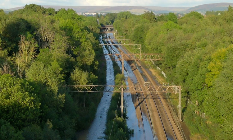
WATCH: Drone footage to assess flooded railway tracks
Posted: 2 September 2022 | Global Railway Review | No comments yet
Network Rail has relased drone footage showing the extent of flooding to railway tracks in east Manchester. Watch the video footage here.
Credit: Network Rail
Specialist drone teams from Network Rail have been surveying the tracks between Gorton and Guide Bridge after a water pipe burst on Thursday 1 September 2022.
Network Rail – the owner and infrastructure manager of most of the railway network in Great Britain – has realased the drone footage (video below) showing the extent of the flooding.
Train services running between Manchester Piccadilly to Leeds via Stalybridge and on the Glossop line have been most impacted, with disruption felt to services for a second day.
Network Rail engineers are assisting the water company with getting access to make repairs to the pipe so that some trains can run again at the same time the repair work takes place beside the tracks.
This isn’t the first time drone technology has been used by Network Rail.
Laser scanners and drones were recently used to map every inch of the iconic Whalley railway viaduct in Lancashire to secure its future for passengers and freight. The 21st century technology is allowing Network Rail to plan essential maintenance which will secure the 19th century structure for the future.
Furthermore, drones were utilised during the extreme heatwave in Britain in July 2022. Network Rail’s extreme weather action teams (EWAT) where equipped with the latest tools to keep passengers and freight moving as best as possible, including a new hi-tech drone and rapid response vehicle. The Emergency Intervention Unit was able to rush to sites and deploy its drone to be the ‘eye in the sky’ during incidents.
Related topics
Adverse Weather, Digitalisation, Drones, Track/Infrastructure Maintenance & Engineering