Network Rail uses laser and drone technology in viaduct restoration project
Posted: 23 November 2020 | Global Railway Review | No comments yet
As part of Network Rail’s £2.1 million Great North Rail Project investment, North Yorkshire’s iconic Ribblehead viaduct was 3D scanned and turned into a computer model by surveyors.
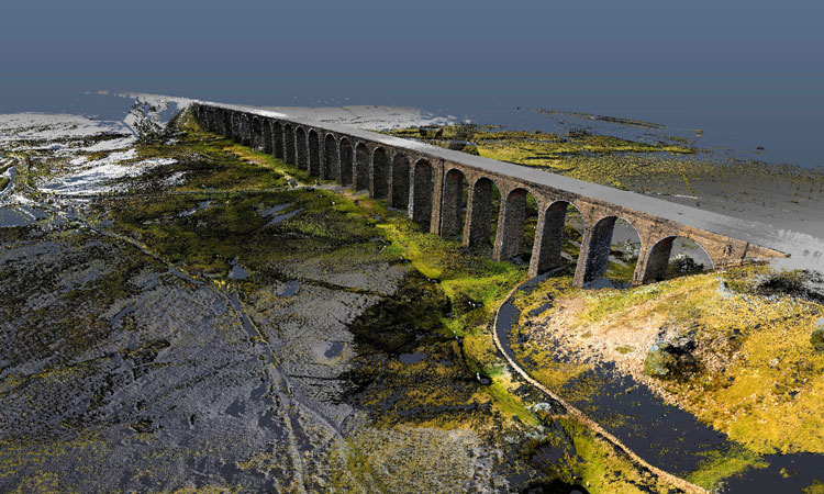
Ribblehead CGI image
Network Rail has used laser scanners and drones to map every inch of North Yorkshire’s iconic Ribblehead viaduct as part of a major restoration project to secure its future for passengers and tourists.
An essential upgrade to brickwork and drainage is underway on the 144-year-old structure which carries the historic Settle to Carlisle railway 400 metres across the Ribble valley.
As part of the £2.1 million Great North Rail Project investment, the Ribblehead viaduct was 3D scanned and turned into a computer model by surveyors. This detailed digital recreation will help engineers make repairs now and closely monitor areas needing any further attention in the future.
Phil James, Network Rail’s North West Route Director, said: “We’re always looking to innovate on the railway and seeing drones and lasers being used to care for such an historic structure is really impressive. I was at Ribblehead viaduct when we started work a week ago and saw for myself the huge scaffolding platforms now in place so my team can improve brickwork, mortar and drainage. Great care and attention is going in to make sure our work is right from a heritage perspective. This digital model plays a major role in that as we secure the Grade II listed-structure’s future for passengers and tourists as part of the Great North Rail Project.”
Network Rail has released impressive footage (video below) of the Victorian viaduct as realised by the 21st century technology. A LiDAR survey was carried out by contractor Commendium in conjunction with heritage consultancy firm Wardell Armstrong.
LiDAR and drone technology
Using LiDAR technology, over 100 separate scans were taken from locations underneath and on top of the viaduct. In a LiDAR system, light is emitted from a rapidly firing laser like a strobe light. This light travels to the ground and reflects off of things such as buildings and tree branches. The reflected light energy then returns to the LiDAR sensor where it is recorded. This data is then used to build up the 3D computer model. The Ribblehead viaduct is the biggest man-made structure Commendium has ever scanned.
Drone flights also took place as part of the survey taking high definition photographs of the Grade II listed structure. The data gathered was then used to build up the 3D computer model by Network Rail’s specialist computer aided design (CAD) team.
Related topics
Big Data, Digitalisation, Drones, Infrastructure Developments, Technology & Software, Track/Infrastructure Maintenance & Engineering