Northern set to launch ‘Street View 3D maps’ for customers
Posted: 12 October 2021 | Global Railway Review | No comments yet
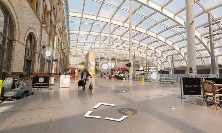
New interactive maps will be added to Northern’s website, offering passengers an opportunity to virtually navigate through the rail operator’s stations in 3D.
Credit: Northern Railway
The Street View 3D maps have been designed to help disabled customers, and anyone who is anxious about travelling, to build confidence and familiarity.
The maps will enable customers to move through Northern’s stations in an interactive way and find facilities such as: ticket offices, toilets, and platforms.
Work is under way to create the maps using 3D scanning – with Manchester Victoria already available to use, and they will be completed by the end of March 2022.
All of Northern’s stations will also have updated 2D maps, which will be available to customers online by the end of November 2021.
Mark Powles, Commercial and Customer Director at Northern said: “Our customers are the heart of everything we do, and our ultimate goal is to make Northern’s services accessible to all.
“Northern is the first train operator to offer both 3D and 2D maps for our customers and this forms part of our wider project to transform our network and encourage people to use public transport – no matter their circumstances.”
“This project is part of our wider programme of improvements, such as the introduction of 101 new trains now complete, the full refurbishment of all older trains, and enhancements at many stations – including improved accessibility to encourage all our customers to ‘go do their thing’.”
Related topics
Digitalisation, Passenger Experience/Satisfaction, Passengers With Reduced Mobility (PRM), Rolling Stock Components (Interior/Exterior), Rolling Stock Maintenance, Station Developments, Technology & Software, Virtual Reality (VR)