Ankara-Istanbul high-speed train line project
Posted: 30 April 2007 | | No comments yet
The Ankara-Istanbul High-Speed Train Project is the first high-speed train line of Turkey and is being realized in two phases – the first being the 251km Sincan-Inönü section and the second being the 158km Inönü-Köseköy section. The 24km Ankara-Sincan and 56km long Köseköy-Gebze sections will be completed by being tendered out separately. The 44km Gebze-H.Pafla section has not been included within the scope of the project as it wasn’t included in the scope of Marmaray Project.
The Ankara-Istanbul High-Speed Train Project is the first high-speed train line of Turkey and is being realized in two phases – the first being the 251km Sincan-Inönü section and the second being the 158km Inönü-Köseköy section. The 24km Ankara-Sincan and 56km long Köseköy-Gebze sections will be completed by being tendered out separately. The 44km Gebze-H.Pafla section has not been included within the scope of the project as it wasn’t included in the scope of Marmaray Project.
The Ankara-Istanbul High-Speed Train Project is the first high-speed train line of Turkey and is being realized in two phases – the first being the 251km Sincan-Inönü section and the second being the 158km Inönü-Köseköy section. The 24km Ankara-Sincan and 56km long Köseköy-Gebze sections will be completed by being tendered out separately. The 44km Gebze-H.Pafla section has not been included within the scope of the project as it wasn’t included in the scope of Marmaray Project.
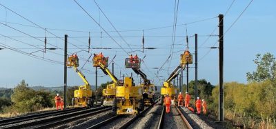
The travel time which is approximately 7 hours between Ankara-Istanbul, will be reduced to 2 hours 30 minutes between Ankara-Gebze and to 3 hours between Ankara-Istanbul when the Ankara-Istanbul High-Speed Train Project is completed, which is constructed as double-line, electrified, signalized, appropriate to 250km/hr with the aim of reducing the travel time between Ankara-Istanbul, the two major cities of our country, and increasing the share of railway in transportation by creating a fast, comfortable, safe transportation opportunity.
Furthermore, the supply of 10 sets of High-Speed Trains, constructions of high-speed train storehouse and new high-speed train Station in Ankara Gar are also included within the scope of the project.
1st Stage: Sincan-Inönü
The construction studies of the 236km Esenkent-Eskiflehir (I·nönü) line, the tender of which was awarded to ALSI·M ALARKO, OHL, G&O, started in 2004 and its test journeys are planned to start during 2007.
Studies of 15km Sincan-Eskis5ehir and 30km Eskis5ehir-I·nönü sections, which are other parts of the project, started in 2006 and the constructions of these sections are planned to be completed in the mid-2007.
2nd Stage: Köseköy- Inönü
The distance between Köseköy-I·nönü is 158km, which is the second stage of the project and was projected in two sections. The first Section is 104km Köseköy-Vezirhan and the second section is 54km between Vezirhan-I·nönü. In this section of the line, the project speed will be applied as 250km/h, minimum curve radii as: 3500 m and slope as: 16%, and the construction studies have been planned to be completed within 24 months.
These sections will be realized by CRCC-CMC-CENGI·Z CONSTRUCTION-IC I·ÇTAS5 CONSTRUCTION CONSORTIUM.
Other sections completing the project
It has been planned to render the section between Köseköy-Gebze, which will ensure the connection of the project with the Marmaray project and which bears the characteristic of being the continuance of the second stage, appropriate to high-speed train operating in years 2007-2008.
The 24km Ankara-Sincan line section will be rearranged and 6 and 5 roads will be constructed in this section as 2 high-speed train lines, 2 suburban lines and 2 conventional lines. The suburban lines will be constructed in subway standards with the aim of easing city transportation.
The rail, sleeper, ballast, connection elements and other minor materials and welds used in the construction of this line undergo inspection and acceptance processes in accordance with technical specifications prepared according to standards UIC, EN and TS and are laid after these processes.
The basic standards that are benefited from while preparing the Technical Specifications can be shortly listed as: UIC 861-3 and EN 13674-1 for rails, EN 13230-(1-2) for sleepers, EN 13 481-2 and EN 13146 (1-8) for connection elements, TS 7043 EN 13450 for ballast and prEN 14730-(1-2), EN 1714, EN 14587 for welds.
Again after the completion of construction of the line, the final position of the line will be measured with railway measuring machine and its provisional acceptance will be made in accordance with ‘Superstructure Studies Acceptance Conditions Technical Specifications’ prepared taking into account tolerances in accordance with prEN 13848-1 norm. After one-year inspection operating, the measurements will be repeated and its final acceptance will be made in accordance with appropriateness to the tolerances.
In projecting of engineering works (viaduct, bridge and vents);
Design loads are determined in accordance with rules and methods included in Part 6 (Project speed 250 km/h) for railway bridges in TSE EN 1991-2 (EUROCODE-1 Part 2: Traffic Load on Bridges) standard.
UIC-71 (Load Model 71) load is being used as design train (vertical moving traffic) load (Load Model SW/0 for constant loads) and 1.40 value is used for vertical load factor “·”.
According to these design loads, static and/or dynamic analyses are made in accordance with rules and methods defined in the standard TSE EN 1991-2 (EUROCODE-1 Part 2: Traffic Load on Bridges).
In the design of reinforced concrete bridges, rules and methods included in the standard TSE EN 1992 (EUROCODE-2 Design of Concrete Structures) and UIC 772-2 code have been taken as a basis.
The criteria included in the standard TS EN 1998 (EUROCODE-8 Design of Structures for Earthquake Part 1: General Rules of Structures for Earthquake Resistance and Part 2: Bridges) and the standard AASHTO have been taken into account in the earthquake effects of engineering works (viaduct, bridge and vents, … etc.).
In the interaction between the railway line and bridge carrier system, the criteria and rules included in the code UIC 774-3 (Track/Bridges Interaction Recommendation for Calculations) are taken into consideration.
In high-speed railway operation, it is obligatory for infrastructure layers to be constructed in a technically correct and satisfactory manner since the defects in the infrastructure will affect the safety more as the speed and axle load increases in superstructure applications with and without ballast. In both type of superstructure applications, it may be required to apply some layers such as formation and protective layer, protective layer against frost, geo-textile and the draining may be required to be sufficient. Required infrastructure studies have been made taking these matters into consideration. All productions performed within the scope of Istanbul high-speed train project have been designed in accordance with (P3) carrying capacity.
In accordance with the information obtained from meteorology data for the Ankara-Istanbul High-Speed Train Project, the frost depth in Eskiflehir and Ankara regions are known as 0.70-0.80. Materials have been selected taking into account the characteristics of material resistant to frost in accordance with KGM specifications.
Geo-textile has not been used since P3 ground is formed as carrying power, moreover, the thickness formed for the formation layer (ballast, sub ballast, sub foundation) is sufficient for the frost depth (0.70-0.80) within the scope of Ankara-Istanbul high-speed train project.
Approach embankments of engineering works
With the aim of preventing different housings in the sections where engineering works (vents, underpass) are present, it has been deemed appropriate to use embankments, which are of better quality than the fillings used in the current embankments, in the sections up to 20 m behind the engineering works.
In approach embankments, materials formed from sand, gravel, crushed stone, rock embankment and mixture thereof are used, and in some type of approach embankments, cement mixture is used as well.
Settlements in embankments
In fillings made on grounds where settlement can occur depending on time: settlement analyses have been made taking into consideration the settlements in the embankment body and the foundation ground as a whole and although it has been calculated when the settlings will be completed using the consolidation coefficients obtained from settlement-time relation laboratory tests, for grounds exceeding h=3 meters and sitting on compressible ground, the duration and situation of completion of settling in productions to be made on the land have been determined with housing plates inserted to the fillings and it has been determined as a result of the performed tests whether it was required to make the other applications to ensure the settlement of 95%, which is accepted as the criteria that will not endanger the safety of navigation at the phase of superstructure construction of embankments.
Filling bevels
Bevel stability analyses have been made taking the most critical point as a basis in the critical sections of filling bevels, and 5-m wide floats have been formed as one each in every 10 m in fillings the height of which exceed 10 m.
Applications made aimed at Stabilization in Splitting Bevels and Erosion Control:
Various methods have been applied for the splitting float grades, stabilization of local slides formed in the bevels and erosion measures in the parts of 1st, 2nd and 3rd Sections within the scope of Ankara-Eskiflehir High-Speed Train Project.
The following methods have been applied against erosion in the sub float:
- Mortared Stone Wall: In general, mortar wall application has been made 2 m in height. The basic width of the stone wall is around 1.2 m and the front side slope 1Y:4D (The dimensions have been adjusted in accordance with the situation of the slope). The stone wall is also used with the aim of preventing the draining channels to be filled quickly due to sheet erosion as well as supporting the bevel overfall in places deemed necessary.
- Stone Facing: Coating application has been made with stones in equal sizes (approximate size 100mm-300mm each) in low-slope bevel sides. Stone coating work has been applied as dry or mortared in splits where sheet erosion is high. Dry stone facing has been applied in sides, the slope grades of which are 3Y:2D or more inclined than this bevel slope.
- Diamond-mesh lath: It has been applied with the aim of preventing the blocked material, inside the fine matrix, to fall to the road in case it breaks away. This lattice system is in the form of fixing 2.7 mm think galvanized wire with 7 cm opening to the rock. The general application size is 2m*20m.
- Botanical soil coating: Plantation has been made by applying botanical soil coating without taking an additional measure in splits, the side slope of which is 2Y:1D or that is more inclined. This method has been applied in filling sides.
Karstic gaps
Karstic dissolving gaps have been found in the formation constituted of marl-clay-sandstone and gypsum during opening of the 442+200-443+700 split within the scope of Ankara – Railway line high-speed Train project. Ground drillings have been opened in order to research the mentioned split. Then, detailed scanning of the split has been made with Geophysics methods. The drillings have been correlated with geophysics methods and the sizes of the gaps have been determined. Then, improvement processes have been realized.
Geology
The geological condition of this split is formed from Neogenic old formation settled in evaporate environment, formed from marl-clay stone and plaster stone. The formation bears ground characteristics due to the litologic structure of the decomposition formation and the Neogenic structure and since Neogenic old formations have not undergone full diagenesis yet. The formation displays rock characteristics in only some sections. Therefore, karstic dissolving gaps are not observed in the ground that bears rock characteristics. It is assumed that karstic dissolving gaps in the sections that bear ground characteristics will be covered with settlement. The dominant source is plaster stone here. The plaster stones form small-scale karstic dissolving channels. (Dr. O. S5ims5ek SIAL)
Geophysic Methods: Resistivity etude
It is required to choose the most appropriate manner in accordance with the geologic problem. In this study, Schlumberger electrode expansion has been used. The undesired damaging effects of the side formations are decreased in this expansion system and effective penetration depth increases.
Both current electrodes (A and B) and potential electrodes (M and N) have been placed symmetrically according to the zero point in the Schlumberger electrode array.
Here, our objective is to find the real impedance and thicknesses of the layers under ground. In order to achieve this aim, current has been given to ground from two points on the ground and the potential difference between the two other points has been measured. The distance between the current electrodes has been increased at the end of each measurement for graphing the impedance based on depth. Thus, it has been possible to ensure the current to do deeper by increasing the distance between current electrodes and thus, receive response from deeper points and learn the impedance characteristics of deeper points.
Whatever the electrode expansion is, measurement has been taken by expanding to the sides at the end of each measurement in a symmetric manner as taking the point that is wanted to be explored as the center, therefore, the fixed point, namely the point that was wanted to be explored has been explored to the depths.
Seismic etude
The geologic structure of the underground has been sampled after the vibration, which was formed by exploding dynamites under the shallow drilling wells or by leaving a heavy object to the ground, has been recorded on geophones and seismographs placed at certain distances from the point of throwing.
Measurement has been taken by breaking of waves along the interface between two rock layers in order to set forth the structural information with basic seismic searching technique.
The speeds, gradients, depths of the layers have been found from the gradients of the time-distance curves from the speeds we have obtained in the land with refraction method and the map of a certain discontinuity has been made.
Land application and evaluation
Original resistivity device, operating with low-frequency alternative current, has been used in the performed etude. The device consisted of three parts as; transmitter, receiver and power supply. 12-volt battery has been used as the power supply.
Measurement taking has been made as Vertical Electric Drilling (DES), the searching depth of which was 30 meters, at 30 points determined between the drillings opened with gaps of 50 meters.
DES measures have been evaluated with partial coinciding method with theoretical two layer abacuses using 3 layer assistant abacuses of Orellana Mooney. Naming of the underground layers has been made in accordance with the known impedance values included in the literatures and the well bores opening in the etude field.
American-made 24-bit A7D resolution 12-channel Seisttronix brand digital seismograph has been used in refraction etude in seismic etudes. This 2000-model seismograph accumulates signals and is capable of taking a single record by accumulating the trace constituted in each impact one on the other. In order for longitudinal wave to be formed in the refraction etude, a plate placed on the ground was hit with a 10-kg sledge. The elastic wave, which was formed in this manner, has been recorded selecting 0.5 msn sampling range with digital seismograph. 12 pcs. geophones have been used, lined up in 5-m intervals, in the longitudinal wave refraction etudes made around the well bore opened previously. Layout length is 60 m and the offset distance is 2,5 m.
Drillings
Total 47 pcs. drillings, the depths of which vary between 15 m and 30 m, 771.0 m in length along the split, have been made in two phases. The first phase was aimed at research and has been made generally using rock-bits. The second phase comprises control wells after the filling injection.
Karstic zones and the geologic structure have been determined taking into account the obtained drilling findings and the geophysics data. Since the karst formation has developed along the plaster stone main layers irregularly located within the formation, the shape and size of karstic dissolving gaps are generally irregular and all of them are connected to each other. Furthermore, the maximum depth that the karst formation can go down is the base of Porsuk river. Base of Porsuk river is in accordance with the deepest point where karst formation is determined.
The karstic dissolving gaps, determined between km: 442+875 and km: 443:025 found with drilling and geophysics methods, have been improved by filling with non-pressurized injection. PVC pipes, 70mm in diameter, have been placed up to the top altitude of the gap in the wells where karstic gaps were found. Each well bore has been filled with filling injection up to the outlet. 6 days after completion of the filling process of the wells, control wells have been opened and the effect of the injection has been explored. The injection mixture is water/solid=1:1 as non-pressurized. In the floor section 40% sand 60% cement rate has been applied. Filling injection has been produced in plant and emptied directly to the wells from mixers.